This website was developed by Elzero Networks. Visit our website: www.elzero.com |

Places to stay while you explore the BC Interior. Visit the Bearfoot Canada Travelogue |
A portal to trails, gear and destination in the interior of BC...GO |


A Bearfoot Canada Responsible Travel Initiative |
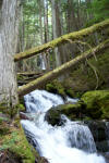
Linking Communities and Southern Interior Trails, Mountains and Watersheds for 2010 |
Okanagan News |

A portal to trails, gear and destination in the interior of BC...GO |
Four years after he died, Bruce Sumner's dream of a High Rim Trail between Kelowna and Vernon is being resurrected. When members of the Nordic Cross Country Ski Club based in Kelowna began working on Sumner's trail this spring, they had no idea that other groups were also working on his trail as well as the much grander Okanagan Highlands Trail. In researching this feature, The Okanagan Saturday discovered: Nordic is working on the High Rim Trail on both sides of Goudie Road in Joe Rich east of Kelowna; Members of the Okanagan chapter of the Back Country Horsemen Association have completed restoration of the High Rim Trail from Beaver Lake to a Telus microwave tower south of Vernon; they are starting the next phase from Postill Lake to Goudie Road, then plan the Postill to Beaver lakes section; A group of Vernon hikers have cleared the High Rim Trail from the tower to Kalamalka Provincial Park in Vernon; Members of Friends of South Slopes have established 80 kilometres of horseback trails south of Mission Creek, some of them likely part of the Okanagan Highlands Trail; The Okanagan Highlands Trail goes through the Browne Lake ecological area past McCulloch Lake (Nordic's cross-country ski trails) to Little White Mountain to Chute Lake Lodge via Big Meadow Lake and Elinor Lake; the new Naramata Conservation Initiative is interested in working with property owners to establish a hiking trail from North Naramata Road to Elinor Lake forest service road, thus providing a direct connection to Naramata and the Okanagan Highlands Trail. By 2007, the centennial of Naramata, it may be possible to hike through forested backcountry from Vernon to Naramata although crossing Beaver and Mission creeks would be difficult Large portions of this Okanagan Highlands Trail would be accessible on horseback as well. Ian Pooley, former chair of the Western Canada Wilderness Commitee's Okanagan chapter for eight years, said the original concept of an Okanagan Highlands Trail in the late 1980s was to start at the Canada-U.S. border and follow both sides of the valley all the way to Armstrong. "It was a very, very ambitious plan although the topography was not conducive in many places because of the deep canyons and side valleys," Pooley said this week. "Parts of it were built and it helped spread the idea as a valley-wide issue." Sumner decided to build the 55-kilometre forested section from Joe Rich east of Kelowna to Kalamalka Provincial Park in Vernon, a relatively easy section compared to some of the other valley topography. "The bigger the plan, the more enthusiastic Bruce was," said Pooley. "He started without B.C. Forest Service approval, got the people in Penticton (ministry staff) annoyed but they eventually caved and it was gazetted (documented)." Sumner was a bit of a loner, friends agree. "Bruce would go out by himself for days and days with a chainsaw. He was very proud of it; it was his trail. And Bruce insisted on the name, High Rim Trail," said Pooley Sumner and a handful of retirees worked on the High Rim Trail every Wednesday from May to November for four years or five, depending on which volunteer you talk to. Mary Bailey of Oyama remembers flagging the north end in 1991 and volunteers working on the trail for five years until 1996. When it was completed, volunteers went over the trail section by section so it would all be cleared of brush every three years. Alice Hargreaves of the Central Okanagan Naturalist Club and Nordic Cross Country Ski Club, became interested a year-and-a-half ago because naturalists had hiked most of the trail for the previous nine years. The North and Central Okanagan naturalist clubs declined to take on restoration and maintenance of the High Rim Trail. The Nordic club accepted the challenge in December with the aim of completing the trail from Joe Rich to Vernon in three years, not knowing others were already working on it. The club already maintains and operates more than 120 kilometres of wilderness trails for skiing, snowshoeing, cycling, hiking and nature walks near McCulloch Lake. "It was a perfect fit and everybody's really excited about it," said Hargreaves. "It's the most perfect wilderness place but parts have not been maintained for quite a number of years and have been virtually unusable in places because of the windfall and trails overgrown with vegetation." Club president Ross Sutcliffe added: "We were looking for a Nordic summer project and I think this trail was a good concept because it gives you day hikes from all along the lake. However, no one is going to do the entire Okanagan Highlands Trail all by themselves; it's probably a 20-year project." Twenty-six volunteers have signed up to date and four work parties have cleared and flagged 16 kilometres of trail on either side of Goudie Road in Joe Rich. On June 11, Sutcliffe and Norman May hauled in chainsaws to clear the trail from Goudie Road north to a viewpoint at an elevation of 1,340 metres. Almost 100 trees, which had blown down in just one section of the trail, were removed. "We stopped for lunch on the viewpoint overlooking Okanagan Valley and the lake far below," said Hargreaves. "The view is spectacular from this ridge. Looking from the left, you can see Little White Mountain all the way to Terrace Mountain on the far right. In the distance are the snow-topped mountains of Brent and Apex. In the foreground are Mount Boucherie, just left of McDougall Ridge, and Blue Grouse Mountain on the right." Since then, volunteers have hauled in chainsaws to clear another eight kilometres to Cardinal Creek. Valley First Credit Union in Penticton is sponsoring some of the restoration and the WCWC, which sponsored the original project, will present a $500 cheque on Aug. 9 on the Joe Rich section. One of the biggest complaints from the public was lack of flagging so Nordic is using tough pink and black striped plastic tape designed to last 10 years. Interpretive signs will be posted so hikers can identify the many different types of plants along the trail and trailheads will be marked for easier access. A GPS will be used to document its location, maps produced and made available at Okanagan sporting goods and recreation stores. There are six trailheads on the High Rim Trail from north to south: Cosens Bay in Kalamalka Provincial Park (Vernon), Oyama Lake Road, Beaver Lake Road (both in Lake Country), Postill Lake Road (Ellison), Goudie Road and Philpott Road (both in Joe Rich). Two more work parties are scheduled for Wednesday (July 12) and Aug. 9. Volunteers meet at 7:45 a.m. at the Parkinson Recreation Centre in the southeast corner of the parking lot for carpooling. Call Hargreaves at 769-5812 for more information or to volunteer. As other members of the 1991-95 committee slowed due to age, Arnold Trewhitt, 82, and his wife, Gladys, quietly continued to maintain the Oyama section. "I know the area quite well. It was our playground when we were kids. Working on it brought back old memories," said Trewhitt. However, "the last couple of years we couldn't do it anymore. The chainsaw got heavier and heavier every year. I was thrilled to hear the Nordic club is taking over." His daughter, Trudy, and husband, Matt McKinnon, members of the Back Country Horsemenm spent 100 hours clearing the Beaver Lake Road to microwave tower section last year and another 40 maintaining it this year. "A lot of hours, my dad was right by our side. He was just incredible," said Trudy. "He kind of got me hooked on it. He's made the trail signs for the different groups. Dad is so thrilled hearing all these people are working on it." "It beats working in the kitchen any day," said Doreen Whipple of Oyama. She and her husband, David, joined the Trewhitts in maintaining the Oyama section. "Arnold's done a yeoman's job of looking after the central section," said Bailey. "We tried to make the trail as straight as possible with as many viewpoints as possible. But it's not an easy trail even for the experienced. There are rattlesnakes in Kalamalka, bears in all parts of the trail. People should go prepared." Gordon Wolf, president of the Back Country Horsemen, planned to start at Postill Lake and head toward Goudie Road this spring but said it's been too wet to start. "It might not take too long with the Nordic club working from Goudie Road," he said, then horsemen could attack the Postill to Beaver section. "We have a good chunk of the Okanagan Highlands Trail in Myra-Bellevue Provincial Park," said Penny Gubbels, FOSS secretary. "It would be absolutely amazing to complete the Okanagan Highlands Trail." She now plans to raise the issue at the next directors' meeting. In July 2000, FOSS's Little White committee (chaired by passionate highlands trail fan Mike Whitaker) hosted the Okanagan Highlands Trail Traverse for 50 participants, said Gubbels. Ultra runners from the Kelowna Running Club ran from McCulloch Lake to Chute Lake Lodge (about 58 kilometres) while a group of hikers started near Upper Canyon Lake and hiked to Big Meadow Lake (about 28 kilometres). "The Alpine Club of Kelowna had set up a camp at Crawford Lake where water and snacks were provided. Back Country Horsemen brought the water in on horseback. It was a big success. FOSS tried to run it again in 2001, but it had to be cancelled at the last minute because of heavy rain." Until a few years ago, Pooley cleared the trail in the Little White area by himself. That was after the outdoor recreation class from Kelowna Secondary spent several summers in the 1990s working on the trails. "It would be nice to see the Okanagan Highland Trail name used again," he mused. "It's always been small groups who didn't coordinate with other groups who have worked on projects like this." Anne Mackay, a FOSS director looking after the Joe Rich/Mission Creek trails project and a member of the Endurance Riders of B.C., said teacher Wayne Price and 15 students in the Rutland Senior Secondary's forestry program students spent five days, assisted by Joe Rich residents Pat and Frank Russell, clearing trails which hadn't been used in 10 years. "We're just getting our feet wet. We've had several meetings with the Ministry of Tourism but at this point we have nothing signed to make them official trails," said Mackay. "We hope that this fall we'll be able to clear out an old trail which we call Mission Impossible, located above Mission Creek. Two of our committee members have already flagged the trail and the grunt work will hopefully be done when it is cooler in the fall." Since there are no signs, she doesn't know which of her trails are part of the Okanagan Highlands Trail but was fascinated by the idea of one long trail from Naramata to Vernon. Craig Henderson of Naramata, who offered eco-tours to the Kettle Valley Railway for four years, said most of the trail exists between North Naramata Road to Big Meadow although parts of it pass through private land northeast of Naramata. The new Naramata Conservation Initiative is still in its preliminary planning stages but hopes to work with landowners to establish a publicly accessible trail system, said Henderson, project director. More information is available at its new web site: www.naramataland.org -30- |
Trailbuilders in the Okanagan begin to discover each others efforts. The following is a recent article by J.P. Squire of Okanagan Saturday. |


sponsors |
Places to stay while you explore the BC Interior. Visit the Bearfoot Canada Travelogue |
This website was developed by Elzero Networks. Visit our website: www.elzero.com |
"It really is a revolution"... |
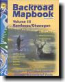
Pick up a copy of the Backroad Mapbook for the Thompson Okanagan. A quality publication with detailed trails and backroads. Available at bookstores everywhere. |